Usage
WMS
Find out what a WMS has to offer. Service metadata:
>>> from owslib.wms import WebMapService
>>> wms = WebMapService('https://mesonet.agron.iastate.edu/cgi-bin/mapserv/mapserv?map=/opt/iem/data/wms/goes/west_ir.map&SERVICE=WMS&REQUEST=GetCapabilities')
>>> wms.identification.type
'OGC:WMS'
>>> wms.identification.version
'1.1.1'
>>> wms.identification.title
'IEM GOES IR WMS Service'
>>> wms.identification.abstract
'IEM generated CONUS composite of GOES IR Satellite.'
Available layers:
>>> list(wms.contents)
['goes_west_ir', 'west_ir_4km', 'west_ir_4km_gray']
Details of a layer:
>>> wms['goes_west_ir'].title
'IEM GOES IR WMS Service'
>>> wms['goes_west_ir'].queryable
0
>>> wms['goes_west_ir'].opaque
0
>>> wms['goes_west_ir'].boundingBox
(-126.0, 24.0, -66.0, 50.0, 'EPSG:4326')
>>> wms['goes_west_ir'].boundingBoxWGS84
(-126.0, 24.0, -66.0, 50.0)
>>> wms['goes_west_ir'].crsOptions
['EPSG:3857', 'EPSG:4326']
Available methods, their URLs, and available formats:
>>> [op.name for op in wms.operations]
['GetCapabilities', 'GetMap', 'GetFeatureInfo', 'DescribeLayer', 'GetLegendGraphic', 'GetStyles']
>>> wms.getOperationByName('GetMap').methods
[{'type': 'Get', 'url': 'https://mesonet.agron.iastate.edu/cgi-bin/mapserv/mapserv?map=/opt/iem/data/wms/goes/west_ir.map&SERVICE=WMS&'}, {'type': 'Post', 'url': 'https://mesonet.agron.iastate.edu/cgi-bin/mapserv/mapserv?map=/opt/iem/data/wms/goes/west_ir.map&SERVICE=WMS&'}]
>>> wms.getOperationByName('GetMap').formatOptions
['image/png', 'image/jpeg', 'image/png; mode=8bit', 'image/vnd.jpeg-png', 'image/vnd.jpeg-png8', 'application/x-pdf', 'image/svg+xml', 'image/tiff', 'application/json']
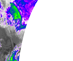
That’s everything needed to make a request for imagery:
>>> img = wms.getmap(layers=['goes_west_ir'],
                     size=(300, 250),
                     bbox=(-126, 24, -66, 50),
                     srs='EPSG:4326',
                     format='image/png')
>>> with open('iem_goes_ir.png', 'wb') as fh:
...     fh.write(img.read())
Result:
WFS
Connect to a WFS and inspect its capabilities.
 >>> from owslib.wfs import WebFeatureService
 >>> wfs20 = WebFeatureService(url='https://services.rce.geovoorziening.nl/dijken/wfs', version='2.0.0')
 >>> wfs20.identification.title
'Landschapsatlas'

 >>> [operation.name for operation in wfs20.operations]
 ['GetCapabilities', 'DescribeFeatureType', 'GetFeature', 'GetPropertyValue', 'ListStoredQueries', 'DescribeStoredQueries',
 'CreateStoredQuery', 'DropStoredQuery', 'ImplementsBasicWFS', 'ImplementsTransactionalWFS', 'ImplementsLockingWFS',
 'KVPEncoding', 'XMLEncoding', 'SOAPEncoding', 'ImplementsInheritance', 'ImplementsRemoteResolve', 'ImplementsResultPaging',
 'ImplementsStandardJoins', 'ImplementsSpatialJoins', 'ImplementsTemporalJoins', 'ImplementsFeatureVersioning',
 'ManageStoredQueries', 'PagingIsTransactionSafe', 'QueryExpressions']
List FeatureTypes
>>> list(wfs20.contents)
['dijken:dijken_bovenregionale_betekenis', 'dijken:dijklijnenkaart_rce']
Download GML using typename, bbox and srsname.
>>> # OWSLib will switch the axis order from EN to NE automatically if designated by EPSG-Registry
>>> response = wfs20.getfeature(typename='dijken:dijklijnenkaart_rce', bbox=(173700,440400,178700,441400), srsname='EPSG:28992')
>>> str(response.read())
'b\'<?xml version="1.0" encoding="UTF-8"?><dijken:dijklijnenkaart_rce...\''
Download in other formats (if supported by server) and pagination.
>>> # Check which output formats are available for GetFeature
>>> [o.parameters['outputFormat']['values'] for o in wfs20.operations if o.name=='GetFeature']
[['application/gml+xml; version=3.2', 'DXF', 'DXF-ZIP', 'GML2', 'KML', 'SHAPE-ZIP', 'application/json', 'application/vnd.google-earth.kml xml',
'application/vnd.google-earth.kml+xml', 'csv', 'gml3', 'gml32', 'json', 'text/csv', 'text/xml; subtype=gml/2.1.2', 'text/xml; subtype=gml/3.1.1', 'text/xml; subtype=gml/3.2']]
>>> response = wfs20.getfeature(typename='dijken:dijklijnenkaart_rce', bbox=(173700,440400,178700,441400), srsname='EPSG:28992', outputFormat='application/json')
>>> response.read()
b'{"type":"FeatureCollection","features":...'
>>> response = wfs20.getfeature(typename='dijken:dijklijnenkaart_rce', srsname='EPSG:4326', maxfeatures=20, startindex=1)
'b\'<?xml version="1.0" encoding="UTF-8"?><dijken:dijklijnenkaart_rce...\''
Return a FeatureType’s schema via DescribeFeatureType. The dictionary returned is
compatible with a Fiona schema object.
>>> wfs20.get_schema('dijken:dijklijnenkaart_rce')
{'properties': {'ogc_fid': 'int', 'id': 'string', 'naam': 'string', 'aanleg_beg': 'string', 'aanleg_ein': 'string', 'aanleg_ind': 'string', 'status': 'string', 'herkomst': 'string', 'verdwenen': 'string', 'oorsprfunc': 'string', 'naspfunc': 'string', 'bijzonderh': 'string', 'bron_data': 'string', 'bron_id': 'string', 'bron_geo': 'string', 'rce_zone': 'string', 'waternaam': 'string', 'polder': 'string', 'shape_leng': 'double', 'opmerking': 'string', 'laatst_bew': 'date'}, 'required': ['ogc_fid'], 'geometry': 'GeometryCollection', 'geometry_column': 'wkb_geometry'}
Download GML using typename and filter.
Usage with WFS 1.1 (FE.1.1):
>>> from owslib.fes import *
>>> from owslib.etree import etree
>>> from owslib.wfs import WebFeatureService
>>> wfs10 = WebFeatureService(url='https://services.rce.geovoorziening.nl/dijken/wfs', version='1.1.0')

>>> filter = PropertyIsLike(propertyname='naam', literal='Haarlemmer*', wildCard='*')
>>> filterxml = etree.tostring(filter.toXML()).decode("utf-8")
>>> response = wfs10.getfeature(typename='dijken:dijklijnenkaart_rce', filter=filterxml)
Usage with WFS 2.0 (FE.2.0):
>>> from owslib.fes2 import *
>>> from owslib.etree import etree
>>> from owslib.wfs import WebFeatureService
>>> wfs11 = WebFeatureService(url='http://geoserv.weichand.de:8080/geoserver/wfs', version='2.0.0')

>>> filter = Filter(
  PropertyIsLike(propertyname='bez_gem', literal='Ingolstadt', wildCard='*')
)
>>> filterxml = etree.tostring(filter.toXML()).decode("utf-8")
>>> response = wfs11.getfeature(typename='bvv:gmd_ex', filter=filterxml)
Save response to a file.
>>> out = open('/tmp/data.gml', 'wb')
>>> out.write(bytes(response.read(), 'UTF-8'))
>>> out.close()
Download GML using StoredQueries(only available for WFS 2.0
services)
>>> from owslib.wfs import WebFeatureService
>>> wfs20 = WebFeatureService(url='https://services.rce.geovoorziening.nl/dijken/wfs', version='2.0.0')

>>> # List StoredQueries
>>> [storedquery.id for storedquery in wfs20.storedqueries]
['urn:ogc:def:query:OGC-WFS::GetFeatureById']

>>> # List Parameters for StoredQuery[0]
>>> [parameter.name for parameter in wfs20.storedqueries[0].parameters]
['ID']

>>> response = wfs20.getfeature(storedQueryID='urn:ogc:def:query:OGC-WFS::GetFeatureById', storedQueryParams={'ID':'dijklijnenkaart_rce.13364'})
>>> str(response.read())
'b\'<?xml version="1.0" encoding="UTF-8"?><dijken:dijklijnenkaart_rce...\''
OGC API
The OGC API standards are a clean break from the traditional OGC service architecture using current design patterns (RESTful, JSON, OpenAPI). As such, OWSLib the code follows the same pattern.
OGC API - Features - Part 1: Core 1.0
>>> from owslib.ogcapi.features import Features
>>> w = Features('https://demo.pygeoapi.io/master')
>>> w.url
'https://demo.pygeoapi.io/master'
>>> conformance = w.conformance()
{'conformsTo': ['http://www.opengis.net/spec/ogcapi-features-1/1.0/conf/core', 'http://www.opengis.net/spec/ogcapi-features-1/1.0/conf/oas30', 'http://www.opengis.net/spec/ogcapi-features-1/1.0/conf/html', 'http://www.opengis.net/spec/ogcapi-features-1/1.0/conf/geojson']}
>>> api = w.api()  # OpenAPI document/
>>> collections = w.collections()
>>> len(collections['collections'])
13
>>> feature_collections = w.feature_collections()
>>> len(feature_collections)
13
>>> lakes = w.collection('lakes')
>>> lakes['id']
'lakes'
>>> lakes['title']
'Large Lakes'
>>> lakes['description']
'lakes of the world, public domain'
>>> lakes_queryables = w.collection_queryables('lakes')
>>> len(lakes_queryables['queryables'])
6
>>> lakes_query = w.collection_items('lakes')
>>> lakes_query['features'][0]['properties']
{'scalerank': 0, 'name_alt': None, 'admin': None, 'featureclass': 'Lake', 'id': 0, 'name': 'Lake Baikal'}
>>> lakes_query = w.collection_items('lakes', name='L. Ontario')
>>> len(lakes_querylakes_query['features'][0]['properties']
{'id': 0, 'scalerank': 0, 'name': 'Lake Baikal', 'name_alt': 'https://en.wikipedia.org/wiki/Lake_Baikal', 'admin': None, 'featureclass': 'Lake'}
OGC API - Coverages - Part 1: Core 1.0
>>> from owslib.ogcapi.coverages import Coverages
>>> w = Coverages('https://dev.api.weather.gc.ca/coverages-demo')
>>> w.url
'https://dev.api.weather.gc.ca/coverages-demo/')
>>> api = w.api()  # OpenAPI document
>>> collections = w.collections()
>>> len(collections['collections'])
3
>>> coverages = w.coverages()
>>> len(coverages)
1
>>> gdps = w.collection('gdps-temperature')
>>> gdps['id']
'gdps-temperature'
>>> gdps['title']
Global Deterministic Prediction System sample'
>>> gdps['description']
'Global Deterministic Prediction System sample'
>>> gdps['extent']['spatial']['grid'][0]
>>> {"cellsCount": 2400, "resolution": 0.15000000000000002 }
>>> gdps['extent']['spatial']['grid'][1]
>>> {"cellsCount": 1201, "resolution": 0.15}
>>> schema = w.collection_schema('gdps-temperature')
>>> len(schema['properties'])
1
>>> schema['properties']['1']['type']
'number'
>> gdps_coverage_data = w.coverage('gdps-temperature', range_subset=[1])
OGC API - Records - Part 1: Core 1.0
>>> from owslib.ogcapi.records import Records
>>> w = Records('https://example.org/records-api')
>>> w.url
'https://example.org/records-api'
>>> conformance = w.conformance()
{'conformsTo': ['http://www.opengis.net/spec/ogcapi-features-1/1.0/conf/core', 'http://www.opengis.net/spec/ogcapi-features-1/1.0/conf/oas30', 'http://www.opengis.net/spec/ogcapi-features-1/1.0/conf/html', 'http://www.opengis.net/spec/ogcapi-features-1/1.0/conf/geojson', 'http://www.opengis.net/spec/ogcapi-records-1/1.0/req/core', 'http://www.opengis.net/spec/ogcapi-records/1.0/req/oas30', 'http://www.opengis.net/spec/ogcapi-records-1/1.0/req/json', 'http://www.opengis.net/spec/ogcapi-records-1/1.0/req/html']}
>>> api = w.api()  # OpenAPI document
>>> collections = w.collections()
>>> len(collections)
1
>>> records = w.records()
>>> len(records)
1
>>> my_catalogue = w.collection('my-catalogue')
>>> my_catalogue['id']
'my-catalogue'
>>> my_catalogue['title']
'My catalogue'
>>> my_catalogue['description']
'My catalogue'
>>> my_catalogue_queryables = w.collection_queryables('my-catalogue')
>>> len(my_catalogue_queryables)
8
>>> my_catalogue_query = w.collection_items('my-catalogue')
>>> my_catalogue_query['features'][0]['properties'].keys()
['title', 'abstract', 'keywords']
>>> my_catalogue_query['features'][0]['properties']['title']
'Roadrunner ambush locations'
>>> my_catalogue_query2 = w.collection_items('my-catalogue', q='birds')
>>> msc_wis_dcpc_query2['numberMatched']
2
>>> msc_wis_dcpc_query2['numberReturned']
2
>>> my_catalogue_cql_text_query = w.collection_items('my-catalogue', filter="title LIKE 'Roadrunner%'")
>>> my_catalogue_cql_text_query['features'][0]['properties']['title']
'Roadrunner ambush locations'
>>> my_catalogue_cql_json_query = w.collection_items('my-catalogue', limit=1, cql={'eq': [{ 'property': 'title' }, 'Roadrunner ambush locations']})
>>> my_catalogue_cql_json_query['features'][0]['properties']['title']
'Roadrunner ambush locations'
>>> import json
>>> record_data = 'sample-geojson-record.json'
>>> with open(record_data) as fh:
..  data = json.load(fh)
>>> identifier = data['id']
>>> w.collection_item_create('my-catalogue', data)
>>> w.collection_item_update('my-catalogue', identifier, data)
>>> w.collection_item_delete('my-catalogue', identifier)
OGC API - Features - Part 4: Create, Replace, Update and Delete
Note
This specification applies to both OGC API - Features and OGC API - Records
>>> import json
>>> from owslib.ogcapi.records import Records

>>> record_data = '/path/to/record.json'

>>> url = 'http://localhost:8000'
>>> collection_id = 'metadata:main'

>>> r = Records(url)

>>> cat = r.collection(collection_id)

>>> with open(record_data) as fh:
...    data = json.load(fh)

>>> identifier = data['id']

>>> r.collection_item_delete(collection_id, identifier)

# insert metadata
>>> r.collection_item_create(collection_id, data)

# update metadata
>>> r.collection_item_update(collection_id, identifier, data)

# delete metadata
>>> r.collection_item_delete(collection_id, identifier)
OGC API - Processes - Part 1: Core 1.0
>>> from owslib.ogcapi.processes import Processes
>>> p = Processes(SERVICE_URL)

>>> processes = p.processes()
>>>  hello_world = p.process('hello-world')

>>> hello_world['id']
'hello-world'
>>> hello_world['title']
'Hello World'

>>> result = p.execute('hello-world', inputs={'name': 'World', 'message': 'Testing from OWSLib'})
>>> result
{'outputs': [{'id': 'echo', 'value': 'Hello World! Testing from OWSLib'}]}
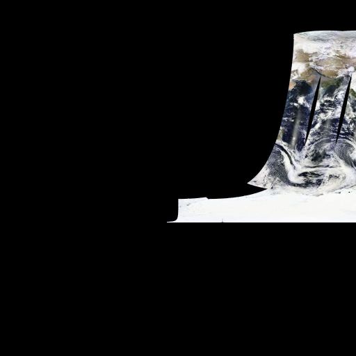
OGC API - Maps - Part 1: Core 1.0
>>> from owslib.ogcapi.maps import Maps
>>> m = Maps('http://localhost:5000')
>>> lakes = m.collection('lakes')
>>> data = m.map('lakes', width=1200, height=800, transparent=False)
>>> with open("output.png", "wb") as fh:
...     fh.write(data.getbuffer())
OGC API - Environmental Data Retrieval - Part 1: Core 1.0
>>> from owslib.ogcapi.edr import EnvironmentalDataRetrieval
>>> e = EnvironmentalDataRetrieval('http://localhost:5000')
>>> icoads_sst = m.collection('icoads-sst')
>>> data = e.query_data('icoads_sst', 'position', coords='POINT(-75 45)', parameter_names=['SST', 'AIRT'])
OGC API - Connected Systems - Part 1: Feature Resources & Part 2: Dynamic Data
Note
The library covers all of parts 1 and 2, the example below is a short overview of the functionality. All CRUD operations are performed in a very similar manner. Please see the Connected Systems API docs for the full lists of properties, encoding requirements and expected responses.
>>> from owslib.ogcapi.connectedsystems import Systems, Datastreams, Observations
>>> s = Systems('http://localhost:5000', auth=('user', 'password'), headers={'Content-Type': 'application/sml+json'})
>>> ds = Datastreams('http://localhost:5000', auth=('user', 'password'), headers={'Content-Type': 'application/json'})
>>> obs = Observations('http://localhost:5000', auth=('user', 'password'), headers={'Content-Type': 'application/json'})
# insert a new system, datastream and observation
>>> system_info =  {
>>>     "type": "SimpleProcess",
>>>     "uniqueId": "urn:osh:sensor:testsmlsensor:001",
>>>     "label": "Test SML Sensor",
>>>     "description": "A Sensor created from an SML document",
>>>     "definition": "http://www.w3.org/ns/ssn/Sensor"
>>> }
>>> ds_definition = {
>>>        "name": "Test Datastream",
>>>        "outputName": "Test Output #1",
>>>        "schema": {
>>>            "obsFormat": "application/swe+json",
>>>            "encoding": {
>>>                "type": "JSONEncoding",
>>>                "vectorAsArrays": False
>>>            },
>>>            "recordSchema": {
>>>                "type": "DataRecord",
>>>                "label": "Test Datastream Record",
>>>                "updatable": False,
>>>                "optional": False,
>>>                "definition": "http://test.com/Record",
>>>                "fields": [
>>>                   {
>>>                       "type": "Time",
>>>                       "label": "Test Datastream Time",
>>>                       "updatable": False,
>>>                       "optional": False,
>>>                       "definition": "http://test.com/Time",
>>>                       "name": "timestamp",
>>>                       "uom": {
>>>                           "href": "http://test.com/TimeUOM"
>>>                       }
>>>                   },
>>>                   {
>>>                       "type": "Boolean",
>>>                       "label": "Test Datastream Boolean",
>>>                       "updatable": False,
>>>                       "optional": False,
>>>                       "definition": "http://test.com/Boolean",
>>>                       "name": "testboolean"
>>>                   }
>>>               ]
>>>           }
>>>       }
>>>   }
>>> observation = {
>>>            "phenomenonTime": the_time,
>>>            "resultTime": the_time,
>>>            "result": {
>>>                "timestamp": datetime.now().timestamp() * 1000,
>>>                "testboolean": True
>>>            }
>>>        }
>>> s.create_system(system_info)
>>> system_id = s.resource_headers['Location'][0].split('/')[-1]
>>> ds.create_datastream(system_id, ds_definition)
>>> ds_id = ds.resource_headers['Location'][0].split('/')[-1]
>>> obs.create_observation(ds_id, observation)
>>> obs_id = obs.resource_headers['Location'][0].split('/')[-1]
>>> # retrieve the observations of our datastream
>>> observations = obs.get_observations(ds_id)['items']
>>>
WCS
>>> # Import OWSLib in Python once installed
... from owslib.wcs import WebCoverageService

>>> # Create coverage object
... my_wcs = WebCoverageService('http://ows.rasdaman.org/rasdaman/ows',
...                             version='2.0.1')

>>> # Get list of coverages
... print my_wcs.contents.keys()
['RadianceColor', 'test_irr_cube_2', 'test_mean_summer_airtemp', 'test_double_1d', 'INSPIRE_EL', 'AverageChlorophyllScaled', 'INSPIRE_OI_RGB', 'Temperature4D', 'INSPIRE_OI_IR', 'visible_human', 'INSPIRE_WS_LC', 'meris_lai', 'climate_earth', 'mean_summer_airtemp', 'multiband', 'ls8_coastal_aerosol', 'NN3_3', 'NN3_2', 'NN3_1', 'NN3_4', 'AvgTemperatureColorScaled', 'AverageChloroColorScaled', 'lena', 'Germany_DTM', 'climate_cloud', 'FiLCCoverageBit', 'AverageChloroColor', 'LandsatMultiBand', 'RadianceColorScaled', 'AvgLandTemp', 'NIR', 'BlueMarbleCov']

>>> # Get geo-bounding boxes and native CRS
... my_wcs.contents['AverageChlorophyllScaled'].boundingboxes
[{'nativeSrs': 'http://ows.rasdaman.org/def/crs-compound?1=http://ows.rasdaman.org/def/crs/EPSG/0/4326&2=http://ows.rasdaman.org/def/crs/OGC/0/UnixTime', 'bbox': (-90.0, -180.0, 90.0, 180.0)}]

>>> # Get axis labels
... my_wcs.contents['AverageChlorophyllScaled'].grid.axislabels
['Lat', 'Long', 'unix']

>>> # Get dimension
... my_wcs.contents['AverageChlorophyllScaled'].grid.dimension
3

>>> # Get grid lower and upper bounds
... my_wcs.contents['AverageChlorophyllScaled'].grid.lowlimits
['0', '0', '0']

>>> my_wcs.contents['AverageChlorophyllScaled'].grid.highlimits
['119', '239', '5']

>>> # Get offset vectors for geo axes
... my_wcs.contents['AverageChlorophyllScaled'].grid.offsetvectors
[['-1.5', '0', '0'], ['0', '1.5', '0'], ['0', '0', '1']]

>>> # For coverage with time axis get the date time values
... my_wcs.contents['AverageChlorophyllScaled'].timepositions
[datetime.datetime(2015, 1, 1, 0, 0), datetime.datetime(2015, 2, 1, 0, 0), datetime.datetime(2015, 3, 1, 0, 0), datetime.datetime(2015, 4, 1, 0, 0), datetime.datetime(2015, 5, 1, 0, 0), datetime.datetime(2015, 7, 1, 0, 0)]
CSW
Connect to a CSW, and inspect its properties:
>>> from owslib.csw import CatalogueServiceWeb
>>> csw = CatalogueServiceWeb('http://geodiscover.cgdi.ca/wes/serviceManagerCSW/csw')
>>> csw.identification.type
'CSW'
>>> [op.name for op in csw.operations]
['GetCapabilities', 'GetRecords', 'GetRecordById', 'DescribeRecord', 'GetDomain']
Get supported resultType’s:
>>> csw.getdomain('GetRecords.resultType')
>>> csw.results
{'values': ['results', 'validate', 'hits'], 'parameter': 'GetRecords.resultType', 'type': 'csw:DomainValuesType'}
>>>
Search for bird data:
>>> from owslib.fes import PropertyIsEqualTo, PropertyIsLike, BBox
>>> birds_query = PropertyIsEqualTo('csw:AnyText', 'birds')
>>> csw.getrecords2(constraints=[birds_query], maxrecords=20)
>>> csw.results
{'matches': 101, 'nextrecord': 21, 'returned': 20}
>>> for rec in csw.records:
...     print(csw.records[rec].title)
...
ALLSPECIES
NatureServe Canada References
Bird Studies Canada - BirdMap WMS
Parks Canada Geomatics Metadata Repository
Bird Studies Canada - BirdMap WFS
eBird Canada - Survey Locations
WHC CitizenScience WMS
Project FeederWatch - Survey Locations
North American Bird Banding and Encounter Database
Wildlife Habitat Canada CitizenScience WFS
Parks Canada Geomatics Metadata Repository
Parks Canada Geomatics Metadata Repository
Wildlife Habitat Canada CitizenScience WMS
Canadian IBA Polygon layer
Land
Wildlife Habitat Canada CitizenScience WMS
WATER
Parks Canada Geomatics Metadata Repository
Breeding Bird Survey
SCALE
>>>
Search for bird data in Canada:
>>> bbox_query = BBox([-141,42,-52,84])
>>> csw.getrecords2(constraints=[birds_query, bbox_query])
>>> csw.results
{'matches': 3, 'nextrecord': 0, 'returned': 3}
>>>
Search for keywords like ‘birds’ or ‘fowl’
>>> birds_query_like = PropertyIsLike('dc:subject', '%birds%')
>>> fowl_query_like = PropertyIsLike('dc:subject', '%fowl%')
>>> csw.getrecords2(constraints=[birds_query_like, fowl_query_like])
>>> csw.results
{'matches': 107, 'nextrecord': 11, 'returned': 10}
>>>
Search for a specific record:
>>> csw.getrecordbyid(id=['9250AA67-F3AC-6C12-0CB9-0662231AA181'])
>>> c.records['9250AA67-F3AC-6C12-0CB9-0662231AA181'].title
'ALLSPECIES'
Search with a CQL query
>>> csw.getrecords(cql='csw:AnyText like "%birds%"')
Transaction: insert
>>> csw.transaction(ttype='insert', typename='gmd:MD_Metadata', record=open("file.xml").read())
Transaction: update
>>> # update ALL records
>>> csw.transaction(ttype='update', typename='csw:Record', propertyname='dc:title', propertyvalue='New Title')
>>> # update records satisfying keywords filter
>>> csw.transaction(ttype='update', typename='csw:Record', propertyname='dc:title', propertyvalue='New Title', keywords=['birds','fowl'])
>>> # update records satisfying BBOX filter
>>> csw.transaction(ttype='update', typename='csw:Record', propertyname='dc:title', propertyvalue='New Title', bbox=[-141,42,-52,84])
Transaction: delete
>>> # delete ALL records
>>> csw.transaction(ttype='delete', typename='gmd:MD_Metadata')
>>> # delete records satisfying keywords filter
>>> csw.transaction(ttype='delete', typename='gmd:MD_Metadata', keywords=['birds','fowl'])
>>> # delete records satisfying BBOX filter
>>> csw.transaction(ttype='delete', typename='gmd:MD_Metadata', bbox=[-141,42,-52,84])
Harvest a resource
>>> csw.harvest('http://host/url.xml', 'http://www.isotc211.org/2005/gmd')
WMC
WPS
Inspect a remote WPS and retrieve the supported processes:
>>> from owslib.wps import WebProcessingService
>>> wps = WebProcessingService('http://cida.usgs.gov/climate/gdp/process/WebProcessingService', skip_caps=True)
>>> wps.getcapabilities()
>>> wps.identification.type
'WPS'
>>> wps.identification.title
'Geo Data Portal WPS Processing'
>>> wps.identification.abstract
'Geo Data Portal WPS Processing'
>>> for operation in wps.operations:
...     operation.name
...
'GetCapabilities'
'DescribeProcess'
'Execute'
>>> for process in wps.processes:
...     process.identifier, process.title
...
('gov.usgs.cida.gdp.wps.algorithm.FeatureCoverageIntersectionAlgorithm', 'Feature Coverage WCS Intersection')
('gov.usgs.cida.gdp.wps.algorithm.FeatureCoverageOPeNDAPIntersectionAlgorithm', 'Feature Coverage OPeNDAP Intersection')
('gov.usgs.cida.gdp.wps.algorithm.FeatureCategoricalGridCoverageAlgorithm', 'Feature Categorical Grid Coverage')
('gov.usgs.cida.gdp.wps.algorithm.FeatureWeightedGridStatisticsAlgorithm', 'Feature Weighted Grid Statistics')
('gov.usgs.cida.gdp.wps.algorithm.FeatureGridStatisticsAlgorithm', 'Feature Grid Statistics')
('gov.usgs.cida.gdp.wps.algorithm.PRMSParameterGeneratorAlgorithm', 'PRMS Parameter Generator')
>>>
Determine how a specific process needs to be invoked - i.e. what are its input parameters, and output result:
>>> from owslib.wps import printInputOutput
>>> process = wps.describeprocess('gov.usgs.cida.gdp.wps.algorithm.FeatureWeightedGridStatisticsAlgorithm')
>>> process.identifier
'gov.usgs.cida.gdp.wps.algorithm.FeatureWeightedGridStatisticsAlgorithm'
>>> process.title
'Feature Weighted Grid Statistics'
>>> process.abstract
'This algorithm generates area weighted statistics of a gridded dataset for a set of vector polygon features. Using the bounding-box that encloses ...
>>> for input in process.dataInputs:
...     printInputOutput(input)
...
 identifier=FEATURE_COLLECTION, title=Feature Collection, abstract=A feature collection encoded as a WFS request or one of the supported GML profiles.,...
 Supported Value: mimeType=text/xml, encoding=UTF-8, schema=http://schemas.opengis.net/gml/2.0.0/feature.xsd
 Supported Value: mimeType=text/xml, encoding=UTF-8, schema=http://schemas.opengis.net/gml/2.1.1/feature.xsd
 Supported Value: mimeType=text/xml, encoding=UTF-8, schema=http://schemas.opengis.net/gml/2.1.2/feature.xsd
 Supported Value: mimeType=text/xml, encoding=UTF-8, schema=http://schemas.opengis.net/gml/2.1.2.1/feature.xsd
 Supported Value: mimeType=text/xml, encoding=UTF-8, schema=http://schemas.opengis.net/gml/3.0.0/base/feature.xsd
 Supported Value: mimeType=text/xml, encoding=UTF-8, schema=http://schemas.opengis.net/gml/3.0.1/base/feature.xsd
 Supported Value: mimeType=text/xml, encoding=UTF-8, schema=http://schemas.opengis.net/gml/3.1.0/base/feature.xsd
 Supported Value: mimeType=text/xml, encoding=UTF-8, schema=http://schemas.opengis.net/gml/3.1.1/base/feature.xsd
 Supported Value: mimeType=text/xml, encoding=UTF-8, schema=http://schemas.opengis.net/gml/3.2.1/base/feature.xsd
 Default Value: mimeType=text/xml, encoding=UTF-8, schema=http://schemas.opengis.net/gml/2.0.0/feature.xsd
 minOccurs=1, maxOccurs=1
 identifier=DATASET_URI, title=Dataset URI, abstract=The base data web service URI for the dataset of interest., data type=anyURI
 Allowed Value: AnyValue
 Default Value: None
 minOccurs=1, maxOccurs=1
 identifier=DATASET_ID, title=Dataset Identifier, abstract=The unique identifier for the data type or variable of interest., data type=string
 Allowed Value: AnyValue
 Default Value: None
 minOccurs=1, maxOccurs=2147483647
 identifier=REQUIRE_FULL_COVERAGE, title=Require Full Coverage, abstract=If turned on, the service will require that the dataset of interest ....
 Allowed Value: True
 Default Value: True
 minOccurs=1, maxOccurs=1
 identifier=TIME_START, title=Time Start, abstract=The date to begin analysis., data type=dateTime
 Allowed Value: AnyValue
 Default Value: None
 minOccurs=0, maxOccurs=1
 identifier=TIME_END, title=Time End, abstract=The date to end analysis., data type=dateTime
 Allowed Value: AnyValue
 Default Value: None
 minOccurs=0, maxOccurs=1
 identifier=FEATURE_ATTRIBUTE_NAME, title=Feature Attribute Name, abstract=The attribute that will be used to label column headers in processing output., ...
 Allowed Value: AnyValue
 Default Value: None
 minOccurs=1, maxOccurs=1
 identifier=DELIMITER, title=Delimiter, abstract=The delimiter that will be used to separate columns in the processing output., data type=string
 Allowed Value: COMMA
 Allowed Value: TAB
 Allowed Value: SPACE
 Default Value: COMMA
 minOccurs=1, maxOccurs=1
 identifier=STATISTICS, title=Statistics, abstract=Statistics that will be returned for each feature in the processing output., data type=string
 Allowed Value: MEAN
 Allowed Value: MINIMUM
 Allowed Value: MAXIMUM
 Allowed Value: VARIANCE
 Allowed Value: STD_DEV
 Allowed Value: SUM
 Allowed Value: COUNT
 Default Value: None
 minOccurs=1, maxOccurs=7
 identifier=GROUP_BY, title=Group By, abstract=If multiple features and statistics are selected, this will change whether the processing output ...
 Allowed Value: STATISTIC
 Allowed Value: FEATURE_ATTRIBUTE
 Default Value: None
 minOccurs=1, maxOccurs=1
 identifier=SUMMARIZE_TIMESTEP, title=Summarize Timestep, abstract=If selected, processing output will include columns with summarized statistics ...
 Allowed Value: True
 Default Value: True
 minOccurs=0, maxOccurs=1
 identifier=SUMMARIZE_FEATURE_ATTRIBUTE, title=Summarize Feature Attribute, abstract=If selected, processing output will include a final row of ...
 Allowed Value: True
 Default Value: True
 minOccurs=0, maxOccurs=1
>>> for output in process.processOutputs:
...     printInputOutput(output)
...
 identifier=OUTPUT, title=Output File, abstract=A delimited text file containing requested process output., data type=ComplexData
 Supported Value: mimeType=text/csv, encoding=UTF-8, schema=None
 Default Value: mimeType=text/csv, encoding=UTF-8, schema=None
 reference=None, mimeType=None
>>>
Submit a processing request (extraction of a climate index variable over a specific GML polygon, for a given period of time), monitor the execution until complete:
>>> from owslib.wps import GMLMultiPolygonFeatureCollection
>>> polygon = [(-102.8184, 39.5273), (-102.8184, 37.418), (-101.2363, 37.418), (-101.2363, 39.5273), (-102.8184, 39.5273)]
>>> featureCollection = GMLMultiPolygonFeatureCollection( [polygon] )
>>> processid = 'gov.usgs.cida.gdp.wps.algorithm.FeatureWeightedGridStatisticsAlgorithm'
>>> inputs = [ ("FEATURE_ATTRIBUTE_NAME","the_geom"),
...            ("DATASET_URI", "dods://cida.usgs.gov/qa/thredds/dodsC/derivatives/derivative-days_above_threshold.pr.ncml"),
...            ("DATASET_ID", "ensemble_b1_pr-days_above_threshold"),
...            ("TIME_START","2010-01-01T00:00:00.000Z"),
...            ("TIME_END","2011-01-01T00:00:00.000Z"),
...            ("REQUIRE_FULL_COVERAGE","false"),
...            ("DELIMITER","COMMA"),
...            ("STATISTICS","MEAN"),
...            ("GROUP_BY","STATISTIC"),
...            ("SUMMARIZE_TIMESTEP","false"),
...            ("SUMMARIZE_FEATURE_ATTRIBUTE","false"),
...            ("FEATURE_COLLECTION", featureCollection)
...           ]
>>> output = "OUTPUT"
>>> execution = wps.execute(processid, inputs, output = "OUTPUT")
Executing WPS request...
Execution status=ProcessStarted
>>> from owslib.wps import monitorExecution
>>> monitorExecution(execution)
Checking execution status... (location=http://cida.usgs.gov/climate/gdp/process/RetrieveResultServlet?id=6809217153012787208)
Execution status=ProcessSucceeded
Execution status: ProcessSucceeded
Output URL=http://cida.usgs.gov/climate/gdp/process/RetrieveResultServlet?id=6809217153012787208OUTPUT.3cbcd666-a912-456f-84a3-6ede450aca95
Alternatively, define the feature through an embedded query to a WFS server:
>>> from owslib.wps import WFSQuery, WFSFeatureCollection
>>> wfsUrl = "http://cida.usgs.gov/climate/gdp/proxy/http://igsarm-cida-gdp2.er.usgs.gov:8082/geoserver/wfs"
>>> query = WFSQuery("sample:CONUS_States", propertyNames=['the_geom',"STATE"], filters=["CONUS_States.508","CONUS_States.469"])
>>> featureCollection = WFSFeatureCollection(wfsUrl, query)
>>> # same process submission as above
...
You can also submit a pre-made request encoded as WPS XML:
>>> request = open('/Users/cinquini/Documents/workspace-cog/wps/tests/resources/wps_USGSExecuteRequest1.xml','rb').read()
>>> execution = wps.execute(None, [], request=request)
Executing WPS request...
Execution status=ProcessStarted
>>> monitorExecution(execution)
Checking execution status... (location=http://cida.usgs.gov/climate/gdp/process/RetrieveResultServlet?id=5103866488472745994)
Execution status=ProcessSucceeded
Execution status: ProcessSucceeded
Output URL=http://cida.usgs.gov/climate/gdp/process/RetrieveResultServlet?id=5103866488472745994OUTPUT.f80e2a78-96a9-4343-9777-be60fac5b256
SOS 1.0
GetCapabilities
Imports
>>> from tests.utils import cast_tuple_int_list, resource_file
>>> from owslib.sos import SensorObservationService
>>> from owslib.fes import FilterCapabilities
>>> from owslib.ows import OperationsMetadata
>>> from owslib.crs import Crs
>>> from datetime import datetime
>>> from operator import itemgetter
Initialize ncSOS
>>> xml = open(resource_file('sos_ncSOS_getcapabilities.xml'), 'rb').read()
>>> ncsos = SensorObservationService(None, xml=xml)
Initialize 52N
>>> xml = open(resource_file('sos_52n_getcapabilities.xml'), 'rb').read()
>>> f2n = SensorObservationService(None, xml=xml)
Initialize NDBC
>>> xml = open(resource_file('sos_ndbc_getcapabilities.xml'), 'rb').read()
>>> ndbc = SensorObservationService(None, xml=xml)
ServiceIdentification
>>> id = ndbc.identification
>>> id.service
'OGC:SOS'
>>> id.version
'1.0.0'
>>> id.title
'National Data Buoy Center SOS'
>>> id.abstract
'National Data Buoy Center SOS'
>>> id.keywords
['Weather', 'Ocean Currents', 'Air Temperature', 'Water Temperature', 'Conductivity', 'Salinity', 'Barometric Pressure', 'Water Level', 'Waves', 'Winds', 'NDBC']
>>> id.fees
'NONE'
>>> id.accessconstraints
'NONE'
ServiceProvider
>>> p = ndbc.provider
>>> p.name
'National Data Buoy Center'
>>> p.url
'http://sdf.ndbc.noaa.gov/'
ServiceContact
>>> sc = p.contactUnused fields should return nothing
>>> sc.role
>>> sc.position
>>> sc.instructions
>>> sc.organization
>>> sc.fax
>>> sc.hours
>>> sc.name 'Webmaster'>>> sc.phone '228-688-2805'>>> sc.address 'Bldg. 3205'>>> sc.city 'Stennis Space Center'>>> sc.region 'MS'>>> sc.postcode '39529'>>> sc.country 'USA'>>> sc.email 'webmaster.ndbc@noaa.gov'
OperationsMetadata
>>> o = ndbc.operations
>>> len(o)
3
Name
>>> len(o)
3
Get by name
>>> getcap = ndbc.get_operation_by_name('GetCapabilities')
>>> isinstance(getcap, OperationsMetadata)
True
Get by name (case insensitive)
>>> getcap = ndbc.get_operation_by_name('getcapabilities')
>>> isinstance(getcap, OperationsMetadata)
True
# GetCapabilities
>>> getcap.constraints
[]
>>> x = getcap.parameters >>> x == {'Sections': {'values': ['ServiceIdentification', 'ServiceProvider', 'OperationsMetadata', 'Contents', 'All']}} True>>> x = sorted(getcap.methods, key=itemgetter('type')) >>> x == [{'type': 'Get', 'url': 'http://sdf.ndbc.noaa.gov/sos/server.php', 'constraints': []}, {'type' : 'Post', 'url': 'http://sdf.ndbc.noaa.gov/sos/server.php', 'constraints': []}] True# DescribeSensor
>>> descsen = ndbc.get_operation_by_name('describesensor')>>> descsen.constraints []>>> x = descsen.parameters >>> x == {'outputFormat': {'values': ['text/xml;subtype="sensorML/1.0.1"']}} True>>> x = sorted(descsen.methods, key=itemgetter('type')) >>> x == [{'type': 'Get', 'url': 'http://sdf.ndbc.noaa.gov/sos/server.php', 'constraints': []}, {'type' : 'Post', 'url': 'http://sdf.ndbc.noaa.gov/sos/server.php', 'constraints': []}] True# GetObservation
>>> getob = ndbc.get_operation_by_name('getobservation')>>> getob.constraints []>>> x = getob.parameters >>> x == {'observedProperty': {'values': ['air_temperature', 'air_pressure_at_sea_level', 'sea_water_electrical_conductivity', 'currents', 'sea_water_salinity', 'sea_floor_depth_below_sea_surface', 'sea_water_temperature', 'waves', 'winds']}} True>>> x = sorted(getob.methods, key=itemgetter('type')) >>> x == [{'type' : 'Get', 'url': 'http://sdf.ndbc.noaa.gov/sos/server.php', 'constraints': []}, {'type' : 'Post', 'url': 'http://sdf.ndbc.noaa.gov/sos/server.php', 'constraints': []}] True
Filter_Capabilities
>>> filter = ndbc.filters
>>> isinstance(filter, FilterCapabilities)
False
- Contents
>>> contents = ndbc.contents >>> len(contents) 848
- Dict access __getitem__
>>> ndbc['station-46084'].name 'urn:ioos:station:wmo:46084'
>>> ndbc['rubbishrubbish'].name Traceback (most recent call last): ... KeyError: 'No Observational Offering with id: rubbishrubbish'
- Network
>>> network = contents['network-all'] >>> network.id 'network-all'
>>> network.name 'urn:ioos:network:noaa.nws.ndbc:all'
>>> network.description 'All stations on the NDBC SOS server'
>>> srs = network.srs >>> isinstance(srs, Crs) True >>> srs.getcodeurn() 'urn:ogc:def:crs:EPSG::4326' >>> srs.getcode() 'EPSG:4326'
# (left, bottom, right, top)
>>> cast_tuple_int_list(network.bbox) [-179, -77, 180, 80] >>> bbsrs = network.bbox_srs >>> isinstance(bbsrs, Crs) True >>> bbsrs.getcodeurn() 'urn:ogc:def:crs:EPSG::4326' >>> bbsrs.getcode() 'EPSG:4326'
>>> bp = network.begin_position >>> isinstance(bp, datetime) True >>> ep = network.end_position >>> isinstance(ep, datetime) True
>>> network.result_model 'om:Observation'
>>> procs = network.procedures >>> len(procs) 847
>>> network.observed_properties ['http://mmisw.org/ont/cf/parameter/air_temperature', 'http://mmisw.org/ont/cf/parameter/air_pressure_at_sea_level', 'http://mmisw.org/ont/cf/parameter/sea_water_electrical_conductivity', 'http://mmisw.org/ont/cf/parameter/currents', 'http://mmisw.org/ont/cf/parameter/sea_water_salinity', 'http://mmisw.org/ont/cf/parameter/sea_floor_depth_below_sea_surface', 'http://mmisw.org/ont/cf/parameter/sea_water_temperature', 'http://mmisw.org/ont/cf/parameter/waves', 'http://mmisw.org/ont/cf/parameter/winds']
>>> foi = network.features_of_interest >>> len(foi) 1082
>>> rfs = network.response_formats >>> len(rfs) 5 >>> rfs[-1] 'application/vnd.google-earth.kml+xml'
>>> rms = network.response_modes >>> len(rms) 1 >>> rms[0] 'inline'
Station
>>> station = contents['station-zbqn7']
>>> station.id
'station-zbqn7'
>>> station.name
'urn:ioos:station:wmo:zbqn7'
>>> station.description
"Zeke's Basin, North Carolina"
>>> srs = station.srs
>>> isinstance(srs, Crs)
True
>>> srs.getcodeurn()
'urn:ogc:def:crs:EPSG::4326'
>>> srs.getcode()
'EPSG:4326'
>>> cast_tuple_int_list(station.bbox)
[-77, 33, -77, 33]
>>> bbsrs = station.bbox_srs
>>> isinstance(bbsrs, Crs)
True
>>> bbsrs.getcodeurn()
'urn:ogc:def:crs:EPSG::4326'
>>> bbsrs.getcode()
'EPSG:4326'
>>> bp = station.begin_position
>>> isinstance(bp, datetime)
True
>>> ep = station.end_position
>>> isinstance(ep, datetime)
True
>>> station.result_model
'om:Observation'
>>> procs = station.procedures
>>> len(procs)
1
>>> procs[0]
'urn:ioos:station:wmo:zbqn7'
>>> ops = station.observed_properties
>>> len(ops)
3
>>> ops[0]
'http://mmisw.org/ont/cf/parameter/sea_water_electrical_conductivity'
>>> foi = station.features_of_interest
>>> len(foi)
1
>>> foi[0]
'urn:cgi:Feature:CGI:EarthOcean'
>>> rfs = station.response_formats
>>> len(rfs)
5
>>> rfs[0]
'text/xml;schema="ioos/0.6.1"'
>>> rm = station.response_modes
>>> len(rm)
1
>>> rm[0]
'inline'
GetObservation
Imports
>>> from tests.utils import resource_file
>>> from owslib.sos import SensorObservationService
>>> from owslib.fes2 import FilterCapabilities
>>> from owslib.ows import OperationsMetadata
>>> from owslib.crs import Crs
>>> from datetime import datetime
>>> from operator import itemgetter
Initialize
>>> xml = open(resource_file('sos_ngwd.xml'),'rb').read()
>>> ngwd = SensorObservationService(None, xml=xml, version='2.0.0')
ServiceIdentification
>>> id = ngwd.identification
>>> id.service
'OGC:SOS'
>>> id.version
'2.0.0'
>>> len(id.profiles)
5
>>> id.title
'GIN SOS'
>>> id.abstract
'GIN SOS mediator'
>>> id.keywords
['water level', 'groundwater level', 'surface water flow']
>>> id.fees
'NONE'
>>> id.accessconstraints
'NONE'
ServiceProvider
>>> p = ngwd.provider>>> p.name 'Geological Survey of Canada, Earth Sciences Sector, Natural Resources Canada, Government of Canada'>>> p.url 'http://gw-info.net'ServiceContact
>>> sc = p.contactUnused fields should return nothing >>> sc.role >>> sc.position ‘Research Scientist’ >>> sc.instructions >>> sc.organization >>> sc.fax ‘+1-613-995-9273’ >>> sc.hours
>>> sc.name 'Boyan Brodaric'>>> sc.phone '+1-613-992-3562'>>> sc.address '615 Booth Street'>>> sc.city 'Ottawa'>>> sc.region>>> sc.postcode 'K1A 0E9'>>> sc.country 'Canada'>>> sc.email 'brodaric at nrcan dot gc dot ca'
OperationsMetadata
>>> o = ngwd.operations >>> len(o) 4Get by name >>> getcap = ngwd.get_operation_by_name(‘GetCapabilities’) >>> isinstance(getcap, OperationsMetadata) True
Get by name (case insensitive) >>> getcap = ngwd.get_operation_by_name(‘getcapabilities’) >>> isinstance(getcap, OperationsMetadata) True
# GetCapabilities >>> getcap.constraints []
>>> x = getcap.parameters >>> x == {'AcceptVersions': {'values': ['2.0.0']}, 'updateSequence': {'values': []}, 'Sections': {'values': ['ServiceIdentification', 'ServiceProvider', 'OperationsMetadata', 'FilterCapabilities', 'Contents', 'All']}, 'AcceptFormats': {'values': ['text/xml', 'application/zip']}} True>>> x = sorted(getcap.methods, key=itemgetter('type')) >>> x == [{'type' : 'Get', 'url': 'http://ngwd-bdnes.cits.nrcan.gc.ca:8080/proxy/GinService/sos/gw?', 'constraints': []}, {'type' : 'Post', 'url': 'http://ngwd-bdnes.cits.nrcan.gc.ca:8080/proxy/GinService/sos/gw', 'constraints': []}] True# DescribeSensor >>> descsen = ngwd.get_operation_by_name(‘describesensor’)
>>> descsen.constraints
[]
>>> x = descsen.parameters >>> x == {'procedureDescriptionFormat': {'values': ['http://www.opengis.net/sensorML/1.0.1']}, 'procedure': {'values': ['urn:ogc:object:Sensor::GIN_GroundwaterLevelProcess']}} True>>> x = sorted(descsen.methods, key=itemgetter('type')) >>> x == [{'type': 'Get', 'url': 'http://ngwd-bdnes.cits.nrcan.gc.ca:8080/proxy/GinService/sos/gw?', 'constraints': []}, {'type' : 'Post', 'url': 'http://ngwd-bdnes.cits.nrcan.gc.ca:8080/proxy/GinService/sos/gw', 'constraints': []}] True# GetObservation >>> getob = ngwd.get_operation_by_name(‘getobservation’)
>>> getob.constraints
[]
>>> x = getob.parameters >>> x == {'srsName': {'values': []}, 'temporalFilter': {'values': []}, 'offering': {'values': ['GW_LEVEL']}, 'result': {'values': []}, 'responseFormat': {'values': ['http://www.opengis.net/waterml/2.0', 'application/zip']}, 'observedProperty': {'values': ['urn:ogc:def:phenomenon:OGC:1.0.30:groundwaterlevel']}, 'procedure': {'values': ['urn:ogc:object:Sensor::GIN_GroundwaterLevelProcess']}} True>>> x = getob.methods >>> x == [{'type' : 'Get', 'url': 'http://ngwd-bdnes.cits.nrcan.gc.ca:8080/proxy/GinService/sos/gw?', 'constraints': []}, {'type': 'Post', 'url': 'http://ngwd-bdnes.cits.nrcan.gc.ca:8080/proxy/GinService/sos/gw', 'constraints': []}] True
Filter_Capabilities
>>> filter = ngwd.filters
>>> isinstance(filter, FilterCapabilities)
False
- Contents
>>> contents = ngwd.contents >>> len(contents) 1
Network >>> network = contents[‘GW_LEVEL’] >>> network.id ‘GW_LEVEL’
>>> network.procedures ['urn:ogc:object:Sensor::GIN_GroundwaterLevelProcess']
>>> srs = network.bbox_srs >>> isinstance(srs, Crs) True >>> srs.id 'http://www.opengis.net/def/crs/EPSG/0/4326'
>>> srs.getcodeurn() 'urn:ogc:def:crs:EPSG::4326'
>>> srs.getcode() 'EPSG:4326'
# (left, bottom, right, top) >>> network.bbox (-120.0, 41.0, -60.0, 60.0)
>>> bbsrs = network.bbox_srs
>>> isinstance(bbsrs, Crs) True
>>> bbsrs.getcodeurn() 'urn:ogc:def:crs:EPSG::4326'
>>> bbsrs.getcode() 'EPSG:4326'
>>> bp = network.begin_position
>>> isinstance(bp, datetime)
True
>>> ep = network.end_position
>>> isinstance(ep, datetime)
True
>>> network.observed_properties
['urn:ogc:def:phenomenon:OGC:1.0.30:groundwaterlevel']
>>> network.response_formats
[]
>>> network.observation_models
[]
SOS 2.0
Examples of service metadata and GetObservation
# Tests using the 52North demo service
>>> from owslib.sos import SensorObservationService
>>> service = SensorObservationService('http://sensorweb.demo.52north.org/52n-sos-webapp/sos/kvp',version='2.0.0')
>>> for content in sorted(service.contents):
...  print(content)
...
http://www.52north.org/test/offering/1
http://www.52north.org/test/offering/2
http://www.52north.org/test/offering/3
http://www.52north.org/test/offering/4
http://www.52north.org/test/offering/5
http://www.52north.org/test/offering/6
http://www.52north.org/test/offering/7
http://www.52north.org/test/offering/8
http://www.52north.org/test/offering/developer
>>> id = service.identification
# Check basic service metadata >>> id.service ‘OGC:SOS’
>>> id.title
'52N SOS'
>>> provider=service.provider
>>> provider.name
'52North'
>>> len(service.operations)
16
# Check allowed params for get FOI
>>> get_foi=service.get_operation_by_name('GetFeatureOfInterest')
>>> try:
...     x = unicode('test')
...     for x in sorted(get_foi.parameters['featureOfInterest']['values']):
...         print(x.encode('utf8'))
... except:
...     for x in sorted(get_foi.parameters['featureOfInterest']['values']):
...         print(x)
http://www.52north.org/test/featureOfInterest/1
http://www.52north.org/test/featureOfInterest/2
http://www.52north.org/test/featureOfInterest/3
http://www.52north.org/test/featureOfInterest/4
http://www.52north.org/test/featureOfInterest/5
http://www.52north.org/test/featureOfInterest/6
http://www.52north.org/test/featureOfInterest/7
http://www.52north.org/test/featureOfInterest/8
http://www.52north.org/test/featureOfInterest/Heiden
http://www.52north.org/test/featureOfInterest/Münster/FE101
http://www.52north.org/test/featureOfInterest/Portland
http://www.52north.org/test/featureOfInterest/TODO
http://www.52north.org/test/featureOfInterest/world
# Check allowed params for get observation
>>> get_obs=service.get_operation_by_name('GetObservation')
get_obs.parameters['responseFormat']['values']
['http://www.opengis.net/om/2.0']
# Get observation call
# Get latest value using O&M reponse format
#’<?xml version=”1.0” encoding=”UTF-8”?>n<sos:GetObservationResponse xmlns:sos=”http://www.opengis.net/sos/2.0” xmlns:xsi=”http://www.w3.org/2001/XMLSchema-instance” xmlns:om=”http://www.opengis.net/om/2.0” xmlns:gml=”http://www.opengis.net/gml/3.2” xmlns:xlink=”http://www.w3.org/1999/xlink” xsi:schemaLocation=”http://www.opengis.net/sos/2.0 http://schemas.opengis.net/sos/2.0/sosGetObservation.xsd http://www.opengis.net/gml/3.2 http://schemas.opengis.net/gml/3.2.1/gml.xsd http://www.opengis.net/om/2.0 http://schemas.opengis.net/om/2.0/observation.xsd”>n <sos:observationData>n <om:OM_Observation gml:id=”o_729058FD6AAFC4701C83D125175F889F51FD4798”>n <om:type xlink:href=”http://www.opengis.net/def/observationType/OGC-OM/2.0/OM_Measurement”/>n <om:phenomenonTime>n <gml:TimeInstant gml:id=”phenomenonTime_2118549”>n <gml:timePosition>2014-07-10T04:31:58.000Z</gml:timePosition>n </gml:TimeInstant>n </om:phenomenonTime>n <om:resultTime xlink:href=”#phenomenonTime_2118549”/>n <om:procedure xlink:href=”http://geoviqua.dev.52north.org/procedures/WXT520”/>n <om:observedProperty xlink:href=”http://geoviqua.dev.52north.org/properties/AirTemperature”/>n <om:featureOfInterest xlink:href=”http://geoviqua.dev.52north.org/stations/Vaisala-WXT520” xlink:title=”Vaisala_WXT520”/>n <om:result xmlns:ns=”http://www.opengis.net/gml/3.2” uom=”degC” xsi:type=”ns:MeasureType”>17.2</om:result>n </om:OM_Observation>n </sos:observationData>n</sos:GetObservationResponse>’ >>> latest_response = service.get_observation(‘http://www.opengis.net/om/2.0’, [‘http://www.52north.org/test/offering/1’], [‘http://www.52north.org/test/observableProperty/1’], eventTime=’om:phenomenonTime,latest’, timeout=120)
Using the GetObservation response decoder for O&M and WaterML2.0 results
# SOS version 2.0 tests using the 52North installation for IOOS: http://ioossos.axiomalaska.com/
# Imports
>>> from owslib.sos import SensorObservationService
>>> from owslib.swe.observation.sos200 import SOSGetObservationResponse
>>> from owslib.etree import etree
# Setup
#>>> service = SensorObservationService(’http://geoviqua.dev.52north.org/SOS-Q/sos/kvp’,version=’2.0.0’)
>>> service = SensorObservationService('http://ioossos.axiomalaska.com/52n-sos-ioos-stable/sos/kvp',version='2.0.0')
# Check allowed params for get observation
>>> get_obs=service.get_operation_by_name('GetObservation')
>>> response = service.get_observation(responseFormat='http://www.opengis.net/om/2.0', offerings=['urn:ioos:station:test:8'], observedProperties=['http://mmisw.org/ont/cf/parameter/sea_water_temperature'], timeout=60)
>>> xml_tree = etree.fromstring(response)
>>> parsed_response = SOSGetObservationResponse(xml_tree)
>>> type(parsed_response)
<class 'owslib.swe.observation.sos200.SOSGetObservationResponse'>
>>> o=parsed_response.observations[0]
## Value changes each call so can’t be tested
## >>> o.get_result().value
>>> o.get_result().uom
'urn:ogc:def:uom:udunits:2:Cel'
# This O&M structure of the results splits each point into an O&M object, resulting in 400 results
>>> len(parsed_response.observations)
400
>>> type(parsed_response.observations[0])
<class 'owslib.swe.observation.om.MeasurementObservation'>
# Get observation for a specific offering (in this case corresponds to a station) and observed property (sea water temperature)
>>> response = service.get_observation(responseFormat='http://www.opengis.net/waterml/2.0', offerings=['urn:ioos:station:test:8'], observedProperties=['http://mmisw.org/ont/cf/parameter/sea_water_temperature'], timeout=60)
>>> xml_tree = etree.fromstring(response)
>>> parsed_response = SOSGetObservationResponse(xml_tree)
>>> type(parsed_response)
<class 'owslib.swe.observation.sos200.SOSGetObservationResponse'>
>>> len(parsed_response.observations)
20
>>> type(parsed_response.observations[0])
<class 'owslib.swe.observation.waterml2.MeasurementTimeseriesObservation'>
>>> type(parsed_response.observations[0].get_result())
<class 'owslib.swe.observation.waterml2.MeasurementTimeseries'>
>>> measurement_timeseries = parsed_response.observations[0].get_result()
>>> len(measurement_timeseries)
20
SensorML
Imports
>>> from tests.utils import resource_file
>>> from owslib.swe.sensor.sml import SensorML
>>> from dateutil import parser
    >>> from datetime import timezone
Initialize
>>> xml = open(resource_file('sml_ndbc_station.xml'), 'rb').read()
>>> root = SensorML(xml)
>>> system = root.members[0]
>>> system.description
'Station metadata for 41012 - 40NM ENE of St Augustine, FL'
Contacts
>>> sorted(system.contacts.keys())
['urn:ogc:def:classifiers:OGC:contactType:operator', 'urn:ogc:def:classifiers:OGC:contactType:publisher']
>>> operators = system.get_contacts_by_role('urn:ogc:def:classifiers:OGC:contactType:operator')
>>> operators[0].role
'urn:ogc:def:classifiers:OGC:contactType:operator'
>>> operators[0].organization
'National Data Buoy Center'
>>> operators[0].country
'US'
>>> publishers = system.get_contacts_by_role('urn:ogc:def:classifiers:OGC:contactType:publisher')
>>> publishers[0].role
'urn:ogc:def:classifiers:OGC:contactType:publisher'
>>> publishers[0].organization
'National Data Buoy Center'
>>> publishers[0].country
'USA'
>>> publishers[0].phone
'228-688-2805'
>>> publishers[0].address
'Bldg. 3205'
>>> publishers[0].city
'Stennis Space Center'
>>> publishers[0].postcode
'39529'
>>> publishers[0].email
'webmaster.ndbc@noaa.gov'
>>> publishers[0].region
'MS'
Identification
>>> sorted(system.identifiers.keys())
['Long Name', 'Short Name', 'StationId']
>>> sid = system.get_identifiers_by_name('StationId')
>>> sid[0].name
'StationId'
>>> sid[0].definition
'urn:ioos:def:identifier:NOAA:stationID'
>>> sid[0].codeSpace
'http://sdf.ndbc.noaa.gov'
>>> sid[0].value
'urn:ioos:station:wmo:41012'
Classifiers
>>> sorted(system.classifiers.keys())
['Platform Type']
>>> classi = system.get_classifiers_by_name('Platform type')
>>> classi[0].name
'Platform Type'
>>> classi[0].definition
'urn:ioos:def:classifier:NOAA:platformType'
>>> classi[0].codeSpace
'http://sdf.ndbc.noaa.gov'
>>> classi[0].value
'MOORED BUOY'
Documents
>>> system.documentation
[<owslib.swe.sensor.sml.Documentation ...>]
>>> doc = system.documentation[0].documents[0]
>>> doc.description
'Handbook of Automated Data Quality Control Checks and Procedures, National Data Buoy Center, August 2009'
>>> doc.format
'pdf'
>>> doc.url
'http://www.ndbc.noaa.gov/NDBCHandbookofAutomatedDataQualityControl2009.pdf'
History
>>> sorted(system.history.keys())
['deployment_start', 'deployment_stop']
>>> his = system.get_history_by_name('deployment_start')
>>> his
[<owslib.swe.sensor.sml.Event ...>]
>>> len(his)
2
>>> event = his[0]
>>> parser.parse(event.date).replace(tzinfo=timezone.utc).isoformat()
'2010-01-12T00:00:00+00:00'
>>> event.description
'Deployment start event'
>>> event.documentation[0].url
'http://sdftest.ndbc.noaa.gov/sos/server.php?service=SOS&request=DescribeSensor&version=1.0.0&outputformat=text/xml;subtype="sensorML/1.0.1"&procedure=urn:ioos:station:wmo:41012:20100112'
ISO
>>> from owslib.iso import *
>>> m=MD_Metadata(etree.parse('tests/resources/9250AA67-F3AC-6C12-0CB9-0662231AA181_iso.xml'))
>>> m.identification.topiccategory
'farming'
>>>
ISO Codelists:
Imports
>>> from tests.utils import resource_file
>>> from owslib.etree import etree
>>> from owslib.iso import CodelistCatalogue
Print testing the code lists
>>> e=etree.parse(resource_file('gmxCodelists.xml'))
>>> c=CodelistCatalogue(e)
>>> sorted(c.getcodelistdictionaries())
['CI_DateTypeCode', 'CI_OnLineFunctionCode', 'CI_PresentationFormCode', 'CI_RoleCode', 'DQ_EvaluationMethodTypeCode', 'DS_AssociationTypeCode', 'DS_InitiativeTypeCode', 'MD_CellGeometryCode', 'MD_CharacterSetCode', 'MD_ClassificationCode', 'MD_CoverageContentTypeCode', 'MD_DatatypeCode', 'MD_DimensionNameTypeCode', 'MD_GeometricObjectTypeCode', 'MD_ImagingConditionCode', 'MD_KeywordTypeCode', 'MD_MaintenanceFrequencyCode', 'MD_MediumFormatCode', 'MD_MediumNameCode', 'MD_ObligationCode', 'MD_PixelOrientationCode', 'MD_ProgressCode', 'MD_RestrictionCode', 'MD_ScopeCode', 'MD_SpatialRepresentationTypeCode', 'MD_TopicCategoryCode', 'MD_TopologyLevelCode', 'MX_ScopeCode']
>>> sorted(c.getcodedefinitionidentifiers('CI_RoleCode'))
['author', 'custodian', 'distributor', 'originator', 'owner', 'pointOfContact', 'principalInvestigator', 'processor', 'publisher', 'resourceProvider', 'user']
CRS Handling
>>> from owslib import crs
>>> c=crs.Crs('EPSG:4326')
>>> c.code
4326
>>> c.getcodeurn()
'urn:ogc:def:crs:EPSG::4326'
>>> c.getcodeuri1()
'http://www.opengis.net/def/crs/EPSG/0/4326'
>>> c.getcodeuri2()
'http://www.opengis.net/gml/srs/epsg.xml#4326'
>>> c=crs.Crs('urn:ogc:def:crs:EPSG::4326')
>>> c.authority
'EPSG'
>>> c.axisorder
'yx'
>>> c=crs.Crs('http://www.opengis.net/gml/epsg.xml#4326')
>>> c.code
4326
>>> c.axisorder
'yx'
>>> c=crs.Crs('urn:x-ogc:def:crs:EPSG:6.11:2192')
>>> c.axisorder
'xy'
>>> c.code
2192
>>> c.version
'6.11'
>>> c=crs.Crs('http://www.opengis.net/def/crs/EPSG/0/4326')
>>> c.authority
'EPSG'
>>> c.code
4326
>>> c.axisorder
'yx'
>>> c=crs.Crs('PROJ4:+proj=lcc +lat_1=46.8 +lat_0=46.8 +lon_0=0 +k_0=0.99987742 +x_0=600000 +y_0=2200000')
>>> c.authority
'PROJ4'
>>> c.code
'+proj=lcc +lat_1=46.8 +lat_0=46.8 +lon_0=0 +k_0=0.99987742 +x_0=600000 +y_0=2200000'
>>> c=crs.Crs('http://www.opengis.net/def/crs/OGC/1.3/CRS84')
>>> c.code
'CRS84'
>>> c.version
'1.3'
>>> c.getcodeurn()
'urn:ogc:def:crs:OGC:1.3:CRS84'
>>> c.getcodeuri1()
'http://www.opengis.net/def/crs/OGC/1.3/CRS84'
Dublin Core
NASA DIF
FGDC
Swiss GM03
Imports
>>> from tests.utils import resource_file
>>> from owslib.etree import etree
>>> from owslib.gm03 import GM03
Print testing some metadata elements
>>> e = etree.parse(resource_file('gm03_example1.xml'))
>>> gm03 = GM03(e)
>>> gm03.header.version
'2.3'
>>> gm03.header.sender
'geocat.ch'
>>> hasattr(gm03.data, 'core')
False
>>> hasattr(gm03.data, 'comprehensive')
True
>>> len(gm03.data.comprehensive.elements)
13
>>> sorted(list(gm03.data.comprehensive.elements.keys()))
['address', 'citation', 'contact', 'data_identification', 'date', 'extent', 'extent_geographic_element', 'geographic_bounding_box', 'identification_point_of_contact', 'keywords', 'metadata', 'metadata_point_of_contact', 'responsible_party']
>>> isinstance(gm03.data.comprehensive.date, list)
True
>>> len(gm03.data.comprehensive.date)
1
>>> gm03.data.comprehensive.metadata.file_identifier
'41ac321f632e55cebf0508a2cea5d9023fd12d9ad46edd679f2c275127c88623fb9c9d29726bef7c'
>>> gm03.data.comprehensive.metadata.date_stamp
'1999-12-31T12:00:00'
>>> gm03.data.comprehensive.metadata.language
'de'
Test TID searching
>>> gm03.data.comprehensive.metadata.tid
'xN6509077498146737843'
>>> search_tid = gm03.data.comprehensive.metadata.tid
>>> gm03.data.comprehensive.get_element_by_tid('404') is None
True
>>> gm03.data.comprehensive.get_element_by_tid(search_tid) is None
False
>>> search_tid2 = gm03.data.comprehensive.extent.data_identification.ref
>>> search_tid2
'xN8036063300808707346'
>>> gm03.data.comprehensive.get_element_by_tid(search_tid2) is None
False
>>> e = etree.parse(resource_file('gm03_example2.xml'))
>>> gm03 = GM03(e)
>>> gm03.data.comprehensive.geographic_bounding_box.extent_type_code
'false'
>>> gm03.data.comprehensive.geographic_bounding_box.north_bound_latitude
'47.1865387201702'
>>> gm03.data.comprehensive.geographic_bounding_box.south_bound_latitude
'47.1234508676764'
>>> gm03.data.comprehensive.geographic_bounding_box.east_bound_longitude
'9.10597474389878'
>>> gm03.data.comprehensive.geographic_bounding_box.west_bound_longitude
'9.23798212070671'
WMTS
Imports
>>> from tests.utils import scratch_file
Find out what a WMTS has to offer. Service metadata:
>>> from owslib.wmts import WebMapTileService
>>> wmts = WebMapTileService("http://map1c.vis.earthdata.nasa.gov/wmts-geo/wmts.cgi")
>>> wmts.identification.type
'OGC WMTS'
>>> wmts.identification.version
'1.0.0'
>>> wmts.identification.title
'NASA Global Imagery Browse Services for EOSDIS'
>>> bytearray(wmts.identification.abstract, 'utf-8')
bytearray(b'Near real time imagery from multiple NASA instruments')
>>> wmts.identification.keywords
['World', 'Global']
Service Provider:
>>> wmts.provider.name
'National Aeronautics and Space Administration'
>>> wmts.provider.url
'https://earthdata.nasa.gov/'
Available Layers:
>>> len(wmts.contents.keys()) > 0
True
>>> sorted(list(wmts.contents))[0]
'AIRS_CO_Total_Column_Day'
Fetch a tile (using some defaults):
>>> tile = wmts.gettile(layer='MODIS_Terra_CorrectedReflectance_TrueColor', tilematrixset='EPSG4326_250m', tilematrix='0', row=0, column=0, format="image/jpeg")
>>> out = open(scratch_file('nasa_modis_terra_truecolour.jpg'), 'wb')
>>> bytes_written = out.write(tile.read())
>>> out.close()
- Test styles for several layers
>>> wmts.contents['MLS_SO2_147hPa_Night'].styles
{'default': {'isDefault': True, 'title': 'default'}}
>>> wmts.contents['MLS_SO2_147hPa_Night'].styles
{'default': {'isDefault': True, 'title': 'default'}}
Test a WMTS without a ServiceProvider tag in Capababilities XML
>>> wmts = WebMapTileService('http://data.geus.dk/arcgis/rest/services/OneGeologyGlobal/S071_G2500_OneGeology/MapServer/WMTS/1.0.0/WMTSCapabilities.xml')
Result:
WaterML
Using WaterML 1.1 for examples
Imports
>>> from tests.utils import resource_file
>>> from owslib.waterml.wml11 import WaterML_1_1 as wml
- An example GetSites response (from cuahsi)
>>> f = open(resource_file('cuahsi_example_all_sites.xml'), 'rb').read()
>>> sites = wml(f).response
- Can view the queryInfo structure for information about the query
>>> sites.query_info.creation_time
datetime.datetime(2009, 6, 12, 10, 47, 54, 531250, tzinfo=tzoffset(None, -25200))
>>> sites.query_info.notes
['ALL Sites(empty request)']
>>> sites.query_info.criteria.method_called
'GetSites'
- Get a list of codes for the sites returned
>>> codes = sites.site_codes
>>> sorted(codes)
[['10105900'], ['USU-LBR-Confluence'], ['USU-LBR-EFLower'], ['USU-LBR-EFRepeater'], ['USU-LBR-EFWeather'], ['USU-LBR-ExpFarm'], ['USU-LBR-Mendon'], ['USU-LBR-Paradise'], ['USU-LBR-ParadiseRepeater'], ['USU-LBR-SFLower'], ['USU-LBR-SFUpper'], ['USU-LBR-Wellsville']]
- Get the names ofthe sites
>>> sorted(sites.site_names)
['East Fork Little Bear River Radio Repeater near Avon, Utah', 'East Fork Little Bear River at Paradise Canal Diversion near Avon, Utah', 'Little Bear River Upper Weather Station near Avon, Utah', 'Little Bear River at McMurdy Hollow near Paradise, Utah', 'Little Bear River at Mendon Road near Mendon, Utah', 'Little Bear River at Paradise, Utah', 'Little Bear River below Confluence of South and East Forks near Avon, Utah', 'Little Bear River near Wellsville, Utah', 'Radio Repeater near Paradise, Utah', 'South Fork Little Bear River above Davenport Creek near Avon, Utah', 'South Fork Little Bear River below Davenport Creek near Avon, Utah', 'Utah State University Experimental Farm near Wellsville, Utah']
- Get a site to view it in more detail
>>> site = sites[codes[0][0]]
>>> site.geo_coords
[('-111.946402', '41.718473')]
>>> site.latitudes
['41.718473']
>>> site.longitudes
['-111.946402']
>>> info = site.site_info
>>> info.notes
[]
>>> x = info.site_properties
>>> x == {'County': 'Cache', 'PosAccuracy_m': '1', 'State': 'Utah', 'Site Comments': 'Located below county road bridge at Mendon Road crossing'}
True
>>> info.altname
>>> info.elevation
'1345'
- An example GetSiteInfo response
>>> f = open(resource_file('cuahsi_example_siteinfo_multiple.xml')).read()
>>> sites = wml(f).response
>>> sites.query_info.criteria.method_called
'GetSiteInfo'
- List codes and names of the sites
>>> codes = sites.site_codes
>>> sorted(codes)
[['USU-LBR-Mendon'], ['USU-LBR-Wellsville']]
>>> sorted(sites.site_names)
['Little Bear River at Mendon Road near Mendon, Utah', 'Little Bear River near Wellsville, Utah']
- Get a site for a closer look
>>> site = sites[codes[1][0]]
>>> site.geo_coords
[('-111.917649', '41.643457')]
- Get the (first) catalog of series for the site
>>> catalog = site[0]
- Get a series from the catalog for a closer look
>>> series = catalog[3]
>>> series.properties
{}
>>> series.begin_date_time
datetime.datetime(2007, 11, 5, 14, 30)
>>> series.end_date_time
datetime.datetime(2008, 4, 5, 20, 30)
>>> series.method_id
'23'
>>> series.source_id
'2'
>>> series.value_count
'7309'
>>> series.value_type
'Field Observation'
>>> series.name
'Turbidity'
>>> series.organization
'Utah State University Utah Water Research Laboratory'
- List variable names and codes
>>> sorted(site.variable_names)
['Battery voltage', 'Gage height', 'Oxygen, dissolved', 'Oxygen, dissolved percent of saturation', 'Phosphorus, total as P', 'Phosphorus, total as P, filtered', 'Solids, total Suspended', 'Specific conductance, unfiltered', 'Temperature', 'Turbidity', 'pH, unfiltered']
>>> sorted(site.variable_codes)
['USU10', 'USU13', 'USU3', 'USU32', 'USU33', 'USU34', 'USU35', 'USU36', 'USU39', 'USU4', 'USU40', 'USU41', 'USU5', 'USU6', 'USU7', 'USU8', 'USU9']
- Get a variable by its code
>>> variable = site['USU7']
>>> variable.variable_name
'Turbidity'
>>> variable.properties
{}
>>> variable.speciation
'Not Applicable'
>>> variable.unit.name
'nephelometric turbidity units'
>>> variable.time_scale.unit.name
'second'
- Example GetValues response
>>> f = open(resource_file('cuahsi_example_get_values.xml')).read()
>>> series = wml(f).response
>>> series.query_info.criteria.method_called
'GetValuesForASite'
- List the names of the series returned (usually None)
>>> series.series_names
[None, None, None, None, None, None, None, None, None, None, None, None]
- List the variables and their codes
>>> sorted(series.variable_names)
['Battery Voltage', 'Battery voltage', 'Gage height', 'Temperature', 'Turbidity']
>>> codes = series.variable_codes
>>> sorted(codes)
['SDSC45', 'USU10', 'USU11', 'USU12', 'USU13', 'USU3', 'USU4', 'USU5', 'USU6', 'USU7', 'USU8', 'USU9']
- Get variables by code
>>> var = series.get_series_by_variable(var_code='USU4')
- Get the first values set from the first variable retrieved from the code
>>> vals = var[0].values[0]
- List (in tuple) the dates and their corresponding measurements
>>> sorted(vals.get_date_values())
[(datetime.datetime(2005, 8, 5, 0, 0), '34.53'), (datetime.datetime(2005, 8, 5, 0, 30), '37.12'), (datetime.datetime(2005, 8, 5, 1, 0), '35.97'), (datetime.datetime(2005, 8, 5, 1, 30), '35.78'), (datetime.datetime(2005, 8, 5, 2, 0), '35.68'), (datetime.datetime(2005, 8, 5, 2, 30), '36.08'), (datetime.datetime(2005, 8, 5, 3, 0), '37.8'), (datetime.datetime(2005, 8, 5, 3, 30), '37.93'), (datetime.datetime(2005, 8, 5, 4, 0), '38.88'), (datetime.datetime(2005, 8, 5, 4, 30), '37.34'), (datetime.datetime(2005, 8, 5, 5, 0), '35.15'), (datetime.datetime(2005, 8, 5, 5, 30), '35.96'), (datetime.datetime(2005, 8, 5, 6, 0), '35.62'), (datetime.datetime(2005, 8, 5, 6, 30), '34.72'), (datetime.datetime(2005, 8, 5, 7, 0), '34.7'), (datetime.datetime(2005, 8, 5, 7, 30), '33.54'), (datetime.datetime(2005, 8, 5, 8, 0), '34.98'), (datetime.datetime(2005, 8, 5, 8, 30), '31.65'), (datetime.datetime(2005, 8, 5, 9, 0), '32.49'), (datetime.datetime(2005, 8, 5, 9, 30), '32.78'), (datetime.datetime(2005, 8, 5, 10, 0), '30.58'), (datetime.datetime(2005, 8, 5, 10, 30), '32.8'), (datetime.datetime(2005, 8, 5, 11, 0), '31.83'), (datetime.datetime(2005, 8, 5, 11, 30), '30.71'), (datetime.datetime(2005, 8, 5, 12, 0), '30.82'), (datetime.datetime(2005, 8, 5, 12, 30), '29.72'), (datetime.datetime(2005, 8, 5, 13, 0), '27.05'), (datetime.datetime(2005, 8, 5, 13, 30), '25.5'), (datetime.datetime(2005, 8, 5, 14, 0), '24.69'), (datetime.datetime(2005, 8, 5, 14, 30), '26.03'), (datetime.datetime(2005, 8, 5, 15, 0), '25.55'), (datetime.datetime(2005, 8, 5, 15, 30), '25.96'), (datetime.datetime(2005, 8, 5, 16, 0), '24.72'), (datetime.datetime(2005, 8, 5, 16, 30), '23.36'), (datetime.datetime(2005, 8, 5, 17, 0), '24.21'), (datetime.datetime(2005, 8, 5, 17, 30), '25.61'), (datetime.datetime(2005, 8, 5, 18, 0), '24.73'), (datetime.datetime(2005, 8, 5, 18, 30), '25.73'), (datetime.datetime(2005, 8, 5, 19, 0), '24.76'), (datetime.datetime(2005, 8, 5, 19, 30), '24.96'), (datetime.datetime(2005, 8, 5, 20, 0), '25.69'), (datetime.datetime(2005, 8, 5, 20, 30), '27.34'), (datetime.datetime(2005, 8, 5, 21, 0), '27.14'), (datetime.datetime(2005, 8, 5, 21, 30), '27.7'), (datetime.datetime(2005, 8, 5, 22, 0), '28.88'), (datetime.datetime(2005, 8, 5, 22, 30), '30.44'), (datetime.datetime(2005, 8, 5, 23, 0), '32.14'), (datetime.datetime(2005, 8, 5, 23, 30), '34.02'), (datetime.datetime(2005, 8, 6, 0, 0), '33.61')]
- Example GetVariables response
>>> f = open(resource_file('cuahsi_example_get_variables.xml')).read() >>> varis = wml(f).response
- Just a list of variables
>>> codes = varis.variable_codes >>> sorted(codes) ['SDSC45', 'USU10', 'USU11', 'USU12', 'USU13', 'USU14', 'USU15', 'USU16', 'USU17', 'USU18', 'USU19', 'USU20', 'USU21', 'USU22', 'USU23', 'USU24', 'USU25', 'USU26', 'USU27', 'USU28', 'USU29', 'USU3', 'USU30', 'USU31', 'USU32', 'USU33', 'USU34', 'USU35', 'USU36', 'USU37', 'USU38', 'USU39', 'USU4', 'USU40', 'USU41', 'USU42', 'USU43', 'USU5', 'USU6', 'USU7', 'USU8', 'USU9'] >>> sorted(varis.variable_names) ['Barometric pressure', 'Battery Voltage', 'Battery voltage', 'Discharge', 'Gage height', 'Oxygen, dissolved', 'Oxygen, dissolved percent of saturation', 'Phosphorus, total as P', 'Phosphorus, total as P, filtered', 'Precipitation', 'Radiation, incoming shortwave', 'Relative humidity', 'Solids, total Suspended', 'Specific conductance, unfiltered', 'Temperature', 'Turbidity', 'Wind direction', 'Wind speed', 'pH, unfiltered'] >>> var = varis[codes[10]] >>> var.variable_name 'Gage height' >>> var.no_data_value '-9999' >>> var.properties {} >>> var.unit.name 'international foot'
OGC OWS Context 1.0.0 Atom CML and GeoJSON Encoding (alpha/under-review)
The OGC OWS Context implementation in OWSlib is currently in alpha and under review, and will still be improved. Please get in touch if you (want to) use it and provide feedback on how more comfortable it should be (especially handling geometries and dates in different encodings) and if it doesn’t treat your “standards-compliant” OWS Context document right. Greatly appreciated :-)
Basic reading/parsing of OGC Web Services Context Documents (OWS Context) in OWC Atom 1.0.0 Encoding and OWC GeoJSON 1.0.0 Encoding Standards:
Imports
>>> import os
>>> from owslib.owscontext.core import OwcContext
>>> from tests.utils import resource_file
Test OWC Atom XML Read
>>> f = open(resource_file(os.path.join('owc_atom_examples', 'wms_meris.xml')), 'rb').read()
>>> owc = OwcContext.from_atomxml(f)
>>> owc.title
'Satellite Image and Countries borders Over France and England'
>>> res = owc.resources[0]
>>> res.id
'http://geoserver.sourceforge.net/html/index.php/'
>>> res.title
'MER_RR__2PRLRA20120406_102429_000026213113_00238_52838_0211.N1.tif'
>>> off = res.offerings[0]
>>> off.offering_code
'http://www.opengis.net/spec/owc-atom/1.0/req/wms'
>>> op = off.operations[0]
>>> op.operations_code
'GetCapabilities'
>>> op.request_url
'http://ows.genesi-dec.eu/geoserver/385d7d71-650a-414b-b8c7-739e2c0b5e76/wms?SERVICE=WMS&VERSION=1.3.0&REQUEST=GetCapabilities'
Test OWC GeoJSON Read
>>> f = open(resource_file(os.path.join('owc_geojson_examples','owc1.geojson')), 'rb').read().decode('utf-8')
>>> owc = OwcContext.from_json(f)
>>> # bcause json works on pure strings, the doctest unicode results for Python 2.7 would cause errors, I add print()
>>> print(owc.title)
WPS 52North example
>>> res = owc.resources[0]
>>> print(res.id)
http://geoprocessing.demo.52north.org:8080/wps/WebProcessingService/process1/
>>> print(res.title)
WPS 52 north
>>> off = res.offerings[0]
>>> print(off.offering_code)
http://www.opengis.net/spec/owc-geojson/1.0/req/wps
>>> op = off.operations[0]
>>> print(op.operations_code)
GetCapabilities
>>> print(op.request_url)
http://geoprocessing.demo.52north.org:8080/wps/WebProcessingService?SERVICE=WPS&VERSION=1.0.0&REQUEST=GetCapabilities
additionally, possibility to construct OWS Context documents from scratch, and then write/serialise into OWC Atom 1.0.0 Encoding or OWC GeoJSON 1.0.0 Encoding Standards:
>>> from owslib.owscontext.core import OwcResource, OwcContext
>>> myContext=OwcContext(id='http://my.url.com/context/id/1',
update_date='2017-11-02T15:24:24.446+12:00',
title='Awesome new Context doc')
>>> myContext.rights='Creative Commons 4.0 BY'
>>> myEntry=OwcResource(id='http://my.url.com/resource/demo-feature-1',
update_date='2017-11-02T15:24:24.446+12:00',
title='This is a feature')
>>> contributor={'name': 'Alex K',
'email': None,
'uri': 'https://allixender.blogspot.com'}
>>> myEntry.authors.append(contributor)
>>> # ... here also continue to build your OGC data offerings, e.g. WMS GetMap etc.
>>> myContext.resources.append(myEntry)
>>> myContext.to_json()
>>> myContext.to_atomxml()
OpenSearch
>>> from owslib.opensearch import OpenSearch
>>> url = 'https://example.org/opensearch'
>>> o = OpenSearch(url)
>>> results = o.search('application/json', productType='SLC') # dict of results