Interact with a WMS¶¶
OGC Web Map Service (WMS) can be used to download map images rendered by the remote server.
Example from the GeoPython Workshop
This is the metadata of the service endpoint:
[1]:
from owslib.wms import WebMapService

wms_url = "https://ows.terrestris.de/osm/service"

wms = WebMapService(wms_url, version="1.3.0")

print(f"WMS version: {wms.identification.version}")
print(f"WMS title: {wms.identification.title}")
print(f"WMS abstract: {wms.identification.abstract}")
print(f"Provider name: {wms.provider.name}")
print(f"Provider address: {wms.provider.contact.address}")
WMS version: 1.3.0
WMS title: OpenStreetMap WMS
WMS abstract: OpenStreetMap WMS, bereitgestellt durch terrestris GmbH und Co. KG. Beschleunigt mit MapProxy (http://mapproxy.org/)
Provider name: terrestris GmbH und Co. KG
Provider address: Kölnstr. 99
Check the Capabilities response directly from the server
Available WMS layers:
[2]:
list(wms.contents)
[2]:
['OSM-WMS',
 'OSM-WMS-no-labels',
 'OSM-Overlay-WMS',
 'TOPO-WMS',
 'TOPO-OSM-WMS',
 'SRTM30-Hillshade',
 'SRTM30-Colored',
 'SRTM30-Colored-Hillshade',
 'SRTM30-Contour',
 'Dark']
[3]:
wms.contents['SRTM30-Colored'].boundingBox
[3]:
(-180.0, -56.0, 180.0, 60.0, 'CRS:84')
[4]:
wms.contents['SRTM30-Colored'].boundingBoxWGS84
[4]:
(-180.0, -56.0, 180.0, 60.0)
[5]:
print(wms['SRTM30-Colored'].crsOptions)
['EPSG:4326', 'EPSG:25832', 'EPSG:900913', 'EPSG:21781', 'EPSG:4258', 'EPSG:2180', 'EPSG:2100', 'EPSG:2056', 'EPSG:29192', 'EPSG:31466', 'EPSG:4839', 'EPSG:3068', 'EPSG:31463', 'EPSG:31468', 'EPSG:29193', 'EPSG:32648', 'EPSG:3857', 'EPSG:4647', 'EPSG:3034', 'EPSG:31467', 'EPSG:3035', 'EPSG:4686', 'EPSG:4674', 'EPSG:25833', 'EPSG:5243']
[6]:
print(wms['SRTM30-Colored'].styles)
{'default': {'title': 'default', 'legend': 'https://ows.terrestris.de/osm/service?styles=&layer=SRTM30-Colored&service=WMS&format=image%2Fpng&sld_version=1.1.0&request=GetLegendGraphic&version=1.1.1', 'legend_width': '155', 'legend_height': '241', 'legend_format': 'image/png'}}
Available methods, their URLs, and available formats:
[7]:
[op.name for op in wms.operations]
[7]:
['GetCapabilities', 'GetMap', 'GetFeatureInfo', 'GetLegendGraphic']
[8]:
wms.getOperationByName('GetMap').methods
[8]:
[{'type': 'Get', 'url': 'https://ows.terrestris.de/osm/service?'}]
[9]:
wms.getOperationByName('GetMap').formatOptions
[9]:
['image/jpeg', 'image/png']
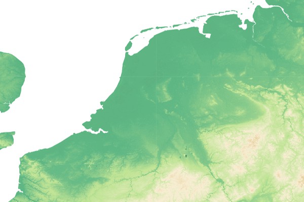
That’s everything needed to make a request for imagery:
[10]:
img = wms.getmap(
    layers=['SRTM30-Colored'],
    size=[600, 400],
    srs="EPSG:4326",
    bbox=[1.0, 50.0, 10.0, 54.0],
    format="image/jpeg")
Result:
[11]:
from IPython.display import Image
Image(img.read())
[11]: